

PSE Research Projects
 |
|
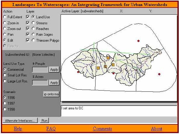
Front-end decision maker interface to the L2W PSE, depicting landuse segmentation of the Upper Roanoke River Watershed in Southwest Virginia. |
development, and indirectly due to the effects of the change, such as increased flooding), and cause economic effects on municipalities (taxes raised versus services provided). The ambitious goal of L2W is to model the effects of landuse and settlement changes by, at a minimum, integrating codes/procedures related to surface and subsurface hydrology, economics, and biology. The development of L2W raises issues far beyond the technical software details, since the cognitive discordance between computer scientists (developing the PSE), civil engineers (surface and subsurface hydrology), economists (land value, taxes, public services), and biologists (water quality, wildlife habitat, species survival) is enormous. The disparity between scientific paradigms in a multidisciplinary engineering design project involving, say, fluid dynamicists, structural, and control engineers is not nearly as significant as that between computer scientists, civil engineers, economists, and biologists. A further compounding factor is that L2W should also be usable by governmental planners and public officials, yet another different set of users.
The architecture of the L2W PSE is based on leveraging existing software tools for hydrology, economic, and biological models into one integrated system. Geographic information system (GIS) data and techniques merge both the hydrologic and economic models with an intuitive web-based user interface. Incorporation of the GIS techniques into the PSE produces a more realistic, site-specific application where a user can create a landuse change scenario based on local spatial characteristics (see Figure). Another advantage of using a GIS with the PSE is that the GIS can obtain necessary parameters for hydrologic and other modeling processes through analysis of terrain, land cover, and other features. Of all the PSEs described here, L2W is unique in that it is centered around a GIS. Currently, L2W integrates surface hydrology codes and economic models for assessing the effect of introducing settlement patterns. Wildlife and fisheries biologists were involved in the L2W project, but their data and models are not fully integrated as of this writing. The biological models include the effect of development on riparian vegetation, water quality, and fish and wildlife species.
Last modified: November 5, 2001